When it comes to First World problems, choosing the best satnav device for motorcycling must be right up near the top of the list. For decades, my idea of motorcycle touring was to plan a route on a good paper map, write down the names of the towns I needed to pass through, place the sheet of paper inside the plastic case on my tank bag, and go.
Then, after a bit of research, I bought a Garmin Zumo 590 LM. It had good reviews, not least because its screen size was a tad larger than most rivals. Users seemed satisfied. I think I paid around £400 for mine and bolted it to the left handlebar of my Valkyrie. I’d fire it up, it would go through the step of acquiring satellites, I’d type in the name of my destination, and it would give me, usually, three route options with varying arrival times.
I liked its features. It would give me an accurate note of my speed, which was usually 2 mph lower than the speedo suggested; it would warn me of the prevailing speed limit; it would warn me of upcoming speed cameras; it would give me a miles-to-destination readout; and I could program it to do other stuff like tell me the time and find hotels and local attractions. It even posted photos of upcoming junctions to make sure I was in the correct lane. It was waterproof and, initially, fairly easy to read.
Then maybe my eyesight started to deteriorate a bit, but I found myself having to stare at the little screen a second or two longer than I wanted. I solved that by connecting my Shoei Neotec 2 and its Sena intercom system to the satnav, and watching the screen was no longer a priority: that standard electronic voice would tell me where I needed to go. So far, so good.
In the meantime, however, I had discovered the joys of Google Maps, which I used extensively in my car. It was so easy to use and it became my main satnav device for the past three years. This year, with motorcycle touring back on the agenda, it was time to get back to the Garmin. And, oh, what a contrast! Its limitations became obvious very quickly.
Tommy Oppegaard from VRCC Norway had taken the trouble to create five or six detailed route maps for us to follow on our summer trip there. I tried to upload them to the Garmin, but that didn’t seem possible. Some online research suggested that it might be possible if I used some new software, but that didn’t work for me either. I watched a tutorial, too, but finally had to agree with a helpful comment that it was very, very hard to do. I gave up and simply wrote down all the towns on Tommy’s maps on a folded piece of A4 and stuck it inside the clear window of my tank bag – just like in the old days!
As a last-minute thought, I went to Halfords to buy a handlebar mounting kit for my phone, thinking I’d use that instead. The requisite hardware came to about £75, which I considered way too much, so we decided to stick with our piece of paper.
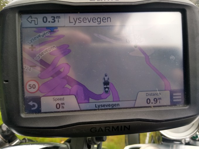
When we got to Calais, I relented and thought I’d enter a destination into the Garmin. Instead of typing in the name of the destination on a full keyboard in mere seconds, of course, I had to go to a sub-menu and select the letter grouping, then enter the name letter by letter, then wait till it found routes. It worked, of course, just fine, once I’d accepted the clunkiness. The audio feed was very helpful, as were the images of major junctions.
Sometimes it just went nuts. We were following an autobahn in Germany and it told me exactly what lane I needed to be in as I approached a junction. As the junction loomed, the purple line indicating the correct route suddenly coloured both directions: straight ahead and right. I went straight and the system had soon rerouted me back to the junction so that I’d take what would have been the right turn. I guess satnavs have off-days. It happened again three times in places where roadworks had completely closed the route. I’d updated the maps just before we set off, but roadworks don’t feature in the Garmin approach, and it refused to search for alternatives, taking us back to the closed road time and time again. We eventually learned to ignore it, follow our noses, and let the satnav resume when we’d got things back on track. I realise that there are probably all kind of functions on the Garmin that I could try to use – the website seems to have lots to say – but frankly I find Google Maps so easy and intuitive that I think I’ll bite that bullet for next year, look into on-board phone charging and invest in a mounting bracket and waterproof case for my Motorola.

I use satnav a lot in the car. Every time I do so I can feel my hippocampus shrinking from neglect, but the convenience overrides any concerns about encroaching dementia. If you’re in the market for a satnav device for your bike, can I suggest you look at Tomtom? For me, their greatest advantage is in understanding real time traffic holdups and dynamically routing you around them. Tomtom appear to have a couple of bike Shoreditch deuces – 500 and 550.
LikeLiked by 1 person
I looked at TomTom when I was buying the Garmin and read several reviews of both. Both had their fans. It seemed at the time that the Garmin just shaded the TomTom (I can’t remember the details now but the screen size and clarity seemed to be pluses). Having invested some £400-odd in one, I can’t justify a further £400-odd on the other! I’m thinking of biting the steep cost of a suitable phone bracket and trying Google Maps, which almost always works for me in the car, and keeping the Garmin as belt and braces…
LikeLike